Ama Dablam Expedition
The ascent of Ama Dablam (6814 M)
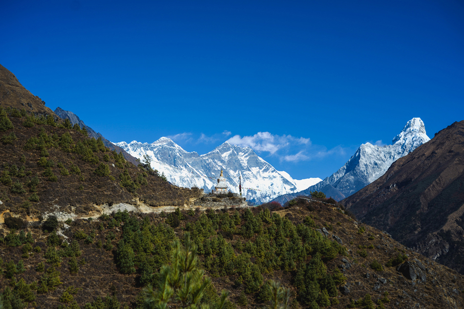
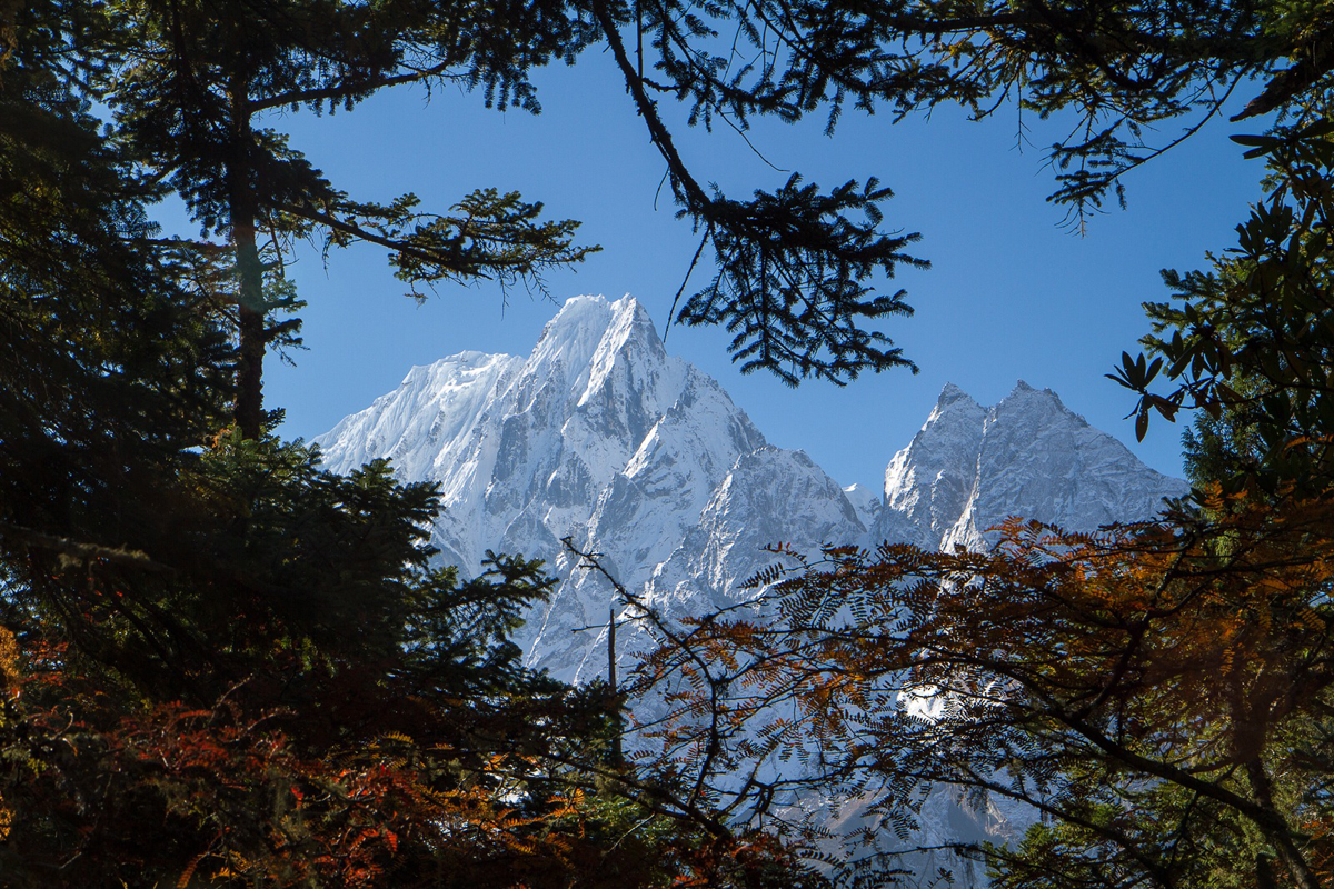
One of the four most beautiful mountains of the world, Ama Dablam, is quite popular among mountaineers. Its proximity to Everest means it shares the approach route through Lukla and Namche Bazaar. At 6,814m it is comparatively lower than the eight-thousanders, but challenging nonetheless.Eight years after the conquest of Mount Everest, Sir Edmund Hillary initiated the first climb of Ama Dablam (Mother’s Necklace” in Nepali) in 1961. The first international expedition to reach the summit by the South-East Ridge route comprised of the American climber Barry Bishop, the Englishman Michael Ward, and two New Zealanders, Wally Romanes and Michael Kennedy. In 1979, the first ascent of the Northern ridge was undertaken by a French expedition.
Ama Dablam, Cervin, Alpamayo, and K2 are considered the four most beautiful mountains in the world. Standing on the summit, one can enjoy incredible views of other 8000 m peaks, including Mount Everest. In 1961, eight years after the conquest of Mount Everest, Edmund Hillary initiated the first climb of Ama Dablam, whose name means "the mother’s necklace" in Nepali. The summit was reached for the first time by its South-Eastern ridge by an international rope group composed of the American man Barry Bishop, the Englishman Michael Ward and the two New Zealanders Wally Romanes and Michael Kennedy. In 1979, the first ascent of the Northern ridge was undertaken by a French expedition. Along with Mounts Cervin, Alpamayo, and K2, Ama Dablam is one of the four most beautiful mountains of the planet. This pyramid of rock and ice is a very good goal for experienced mountain climbers. At the top, one can enjoy a fantastic view of the 8000 m. summits around, including Mount Everest.
Days
Meet with our guide for a briefing.
- Meals on your own.
- Accommodation: Hotel Manaslu or Nepali Ghar on a BB basis.
- Accommodation: As previous day
Early departure from the hotel to reach (TIA) Kathmandu Airport. Followed by a 35 min. flight to Lukla (2,840 m.), the famous airfield in the Khumbu region. The flight is subject to climatic and schedule changes according to the situation. Here, the porters receive their responsibilities and usually, after lunch the trek begins. We start the trek with a descent to Thado Koshigaon (2,550 m.), followed by a gentle ascent along the Dudh Koshi, the “River of Milk”, which leads to Phakding (2,610 m.).
- Breakfast, lunch and dinner included
- Duration of hike: 3 ½ hr.
- Descent: - 220 m.
- Accommodation: Lodge.
We continue up the valley along the Dudh Koshi River followed by a steep climb up to Namche Bazar (3,440 m), the capital of Khumbu ( Sherpa Country). Half-way to Namche Bazar, there are delightful views of Thamserku (6,608 m), Kusum Kanguru (6,367 m) and sometimes even Everest (8,848 m.)
- Breakfast, lunch and dinner included.
- Duration of hike: 5 to 6 hr.
- Ascent: + 945 m.
- Accommodation: Lodge.
This is a day dedicated to acclimatization. We go up across the Bhote Khosi Valley to the village of Thame (3,800 m.) which lies at the crossroads of two valleys: one going to Rolwaling by the Trashi Lapsa (5,755 m.) and the other going to Tibet by the Nangpa La Pass (5,716 m.). We then return to Namche Bazaar retracing our path.
- Breakfast, lunch and dinner included
- Duration of hike: 4 to 5 hr.
- Ascent: + 250 m.
- Descent : - 250 m.
- Accommodation: Lodge
- Breakfast, lunch and dinner included.
- Duration of hike: 4.5 to 5 hr.
- Ascent: + 600 m.
- Descent: - 150 m.
- Accommodation: Lodge.
- Breakfast, lunch and dinner included.
- Duration of hike: 4 ½ to 5 hr.
- Ascent: + 850 m.
- Descent: - 100 m.
- Accommodation: Bivouac under tents.
- Walk between the base camp and the advanced base camp (5,400 m.): the path follows the ridgeline (gentle slope) above the base camp.
- Walk between the advanced base camp (5,400 m.) and Camp 1 (5,800 m.), crossing an area with large blocks of rocks: the cairns. The camp is located above a 100-meter large slab of rock that may be slippery.
- Between Camp 1 and Camp 2 (6000 m.): walk along a "horizontal" ridge with many crossings and passages of several ridges. At the end of this ridge, we can see the "yellow tower": a 6 m-high rise. The camp is slightly above it.
- Between Camp 2 and Camp 3 (6,300 m.): after we leave the camp, there is a steep section of snow or ice. Then, we cross the "gray tower" which is difficult at about 80 m. After a steep crossing, the ridge leading to the camp becomes easier.
- Route between Camp 3 and the summit (6,856 m): We ascend through steep snow slopes (+ 40°) and cross a bergschrund before approaching the summit slope. Once the summit is reached, we enjoy exceptional views of a large number of summits around: 5 of them are more than 8000 m. high: Everest (8,848 m), the top of the world; Kanchenjunga (8,586 m), third highest peak; Lhotse (8,516 m), the fourth; Makalu (8,463 m), the fifth and Cho Oyu (8,201 m), the sixth-highest in the world.
- Accommodation: Bivouac under tents.
- Breakfast, lunch and dinner included.
- Duration of hike: 6 to 7hr
- Ascent: + 250m.
- Descent: - 1500 m.
- Accommodation: Lodge.
- Breakfast, lunch and dinner included.
- Duration of hike: 6.5 to 7hr.
- Ascent: + 400 m.
- Descent: - 1000 m.
- Accommodation: Lodge
Catch the flight back to Kathmandu which is subject to weather and operational changes. In Kathmandu; transfer to your hotel. The latter half of the day is free.
- Accommodation: Hotel Manaslu or Nepali Ghar *** on BB basis.
Free day in Kathmandu, also serves as a spare day in case of cancellations of the flight from Lukla to Kathmandu or delay on the trek. Distribution of certificates.
- Accommodation: Hotel Manaslu or Nepali Ghar *** on BB basis.
- Breakfast included.
End of our services.
- Transfer from the international airport to the hotel and return
- 1 sirdar, 1 cook, and helpers.
- For each climber, 1 Sherpa of altitude (English-speaking) with his equipment
- Hyperbaric chamber
- A satellite phone
- Solar panels for energy
- All transportation from Kathmandu by plane (Kathmandu / Lukla / Kathmandu: 360 US $ / participant)
- Transportation of loads by the porters to the Base Camp (60 kg max per participant)
- Cargo on Lukla/Kathmandu up to 60 kg per participant
- Food during the trek
- Food during the expedition including the altitude camps
- Gas in the Primus altitude camps (not stoves)
- Material: fixed ropes, snow piles, pins, etc.
- The tents in the base camp and the altitude camps for all climbers and Sherpas (North Face)
- Kitchen tent, mess tent, toilet tent, shower tent, chairs, table, kitchen equipment, etc.
- Insurance for the Nepalese team (Sherpas, carriers, liaison officers, cooks)
- Ascension permit (royalties)
- Khumbu trekking permit, tourist tax, and Sagarmatha National Park permit
- "Deposit Garbage"
- Liaison Officer
- Bonus for the Sherpas
- Personal medical insurance (including repatriation)
- Doctor and drugs at the base camp
- Tips for the Nepalese team (porters and cooks) to your initiative
- Summit bonus for Sherpas to your initiative
- Visa for Nepal ($ 40 to get at the airport)
- Alcoholic drinks and soda, lodge room with bathroom, expenses and personal equipment, etc.
- International flights
- Stay in Kathmandu and change of international flight if the trekking time is shortened ( abandon, medical reason, early success, etc ...)
- Extra helicopter cost in case of the cancellation of the plane flight to/from Lukla (from 190 US $ extra/person / flight)
Important: in some cases, depending on availability, early morning flight from Kathmandu, and arrival on the same day at the end of the day. In case of a night flight, the departure will be from Kathmandu at the end of the day and the arrival at destination on Day 28.
Only persons with a plane ticket are allowed to enter the airport.
In Kathmandu, our guides cannot accompany you to the check-in desk.
EQUIPMENT
BAGGAGE
You must pack all of your belongings into 2 bags: 1 backpack and 1 big travel bag.
1 - The backpack:
Mountain backpack with a 60-liter capacity, useful for the transport of your personal belongings during the daytime.
It will also serve as hand luggage while traveling, for all your fragile possessions (camera, etc...), valuable (If there’s no safe-deposit box at your accommodation), and for your possible medications.
It will be with you in the cabin during air transport. Generally, the weight of the cabin luggage is limited to 10 kg per person.
2 - The big travel bag:
It must contain the rest of your belongings. Before you leave, you will receive “Terres d'Aventure” tags, to identify your baggage with your name and address, which will make the bag gathering easier while arriving at the airport. This bag will be in the hold during air transport. The baggage allowance will be indicated on your notification or ticket.
OUR RECOMMENDATION:
-Put whatever is possible in your checked baggage and put only what is absolutely essential for the trip in your hand luggage.
During the flight, take some trekking clothes and your most important garments with you (in case your luggage does not reach the airport in time).
- Please note that security checks have become very strict at airports: put knives, scissors, nail files, and spare batteries in your hold bag.
Strict regulations are applicable for checked and cabin baggage. We strongly advise you to inquire about the various restrictions and to consult the information available on the French administration websites:
https://www.ecologique-solidaire.gouv.fr/liquides-et-objets-interdits-ou-reglementes-en-avion
ABOUT LUGGAGE
- On-site, we provide you a 70-liter duffel bag to make the bag packaging and the porters’ work easier during the trek.
- On domestic flights in Nepal, the baggage allowance is 10 kg per person for checked baggage and 5 kg for hand luggage.
- It is possible to leave your luggage in Kathmandu with some clean clothes for your return and / or what you deem is not useful for trekking.
CLOTHING
For your feet and hands, you must take the greatest care choosing equipment. The best option is often a combination of successive layers. But, be careful, it should not feel too tight. By saving too much money, you risk frostbites.
- 1 pair of high mountain gloves and 1 pair of warm mittens
- 1 pair of very fine fleece gloves and 1 pair of fleece mittens
- 1 pair of Gore-Tex overshoes
- 1 fleece hat, cap, hat, scarf or hood
- 1 thin fleece sweater
- 1 fleece jacket: e.g. Polartec 200, Windstopper or Windpro
- 1 down jacket, to feel comfortable at the camp
- 1 Gore-Tex jacket and pants outfit.
- 1 underwear outfit in Capilene (Patagonia), carline (Millet), dryflo (Lowe Alpine), or light effect (Odlo), etc ...
- 1 trekking pants
- 1 stretch fleece pants for comfort (optional)
- 1 pair of hiking shoes
- 1 pair of very warm high mountain boots
- 1 pair of down slippers (optional, can be purchased at a good price in Kathmandu)
- 2 pairs of wool socks and 1 pair of wool and silk socks (recommended)
- Walking socks
- Short-sleeved T-shirts in Capilene (Patagonia), carline (Millet), dryflo (Lowe Alpine) or light effect (Odlo), etc ...
- Underwear
- 1 pair of gaiters or over-boots
- Rain cape
- 1 shorts or Bermuda shorts
- 1 pair of running shoes and / or sandals
EQUIPMENT
SMALL EQUIPMENT
- 2 pairs of glacier glasses (with side shells)
- 1 ski mask (indispensable in bad weather and windy conditions)
- 1 headlamp
- 1 multi-purpose knife and lighters
- 1 thermos (capacity according to your consumption) and a gourd
- Light toiletries
- Heating pads (optional)
TECHNICAL EQUIPMENT
- 1 mountaineering helmet
- 1 short ice axe
- 1 pair of telescopic ski poles
- 1 pair of crampons and pre-set antibott
- 1 harness
- 1 climbing handle ; like Petzl
- 4 meters of 7 or 8 mm rope ; and 2 m of 5 mm rope
- 1 descender
SLEEPING
- 1 sleeping bag (-10 ° C in "comfort" temperature)
- 1 bag sheet in silk or fleece
- 1 pillowcase for comfort and hygiene
** Possibility to rent a sleeping bag in Kathmandu, - 20° C comfort temperature. To book upon registration, but to be paid on arrival in Nepal (70 € in cash for the entire trip).
Note: rental possibility is subject to availability. It is important to note that the size of the duvets is only suitable for people measuring no more than 180cm.
Plan your own bag sheet.
PERSONAL PHARMACY
- Your usual medications
- Pain medication: preferably Paracetamol
- Anti-diarrhea (Lopémaride, Tiorfan, etc)
- Intestinal adsorbent (Smecta)
- Antibiotic treatment: plan 8 days of treatment (on medical prescription)
- Eye drops (dust, Ophthalmia) and antibiotic cream for the eyes
- Purifying tablets for water (Micropur forte, Aquatabs, etc.)
- Elastic adhesive tape (Elastoplast, 6 cm wide)
- Sets of adhesive bandages and disinfectant compresses
- Double skin bandage, available in sports shops, pharmacy or drugstore ...)
- Anti-inflammatory cream
- Treatment for colds and sore throats (tablets)
- Effective mosquito repellent for tropical zone
- Biafine
- Diamox tablet for prevention or treatment of acute mountain sickness (on medical prescription)
FIRST AID KIT
A complementary collective pharmacy provided by the agency and adapted to your trip is placed under the responsibility of our staff.
MATERIAL PROVIDED
- Tents, mess tent (up to base camp), mattresses, cutlery, bowls, and plates
- Hyperbaric chamber
- Fixed ropes
For your next trek with us in the Himalayas, travel light and aware: Base Camp offers you a biodegradable soap made in Nepal, to leave no trace ...